“What do you want for your birthday?” I asked my Lina.

“An adventure.”

I pulled some levers, pushed some buttons, and made a plan.

Sunday, February 16, 2020. We headed NW on US 183. This was a pleasure trip for ourselves, and I was also keen to preview a new route to West Texas that skips Johnson City and Fredericksburg. Since we abide on Austin’s northeast side, it was refreshing to bypass downtown and Oak Hill traffic.

Sailing was smooth to Seward Junction, where we bore left onto TX 29 and continued through Liberty Hill, Bertram, and Burnet. I pointed out RR 2341, which leads to Reveille Hill Ranch, the site of Utopia Fest each November. Right along there, the rocks dramatically changes from Cretaceous limestone to much older sandstone and granite.

The highway dipped into the Colorado River valley and curved past multiple-arched Buchanan Dam, built in 1937, the first of the Highland Lakes chain. Bluebonnet Lighthouse stands tall here and prevents pleasure craft from running aground. Over a crest, we hugged a railroad and the Llano River and followed both into that city—a misnomer, because llano means flat plain, which this area isn’t.

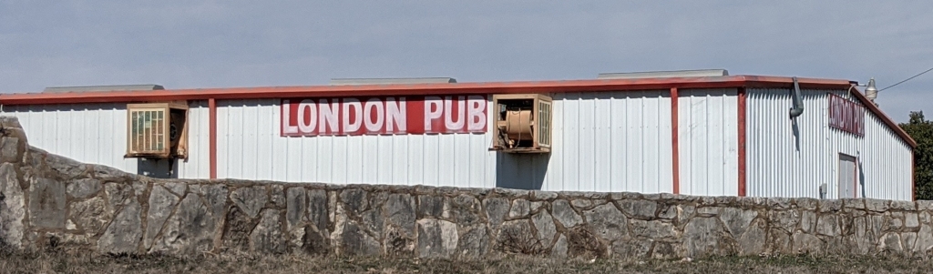
Across Willow Creek is Art, Texas, with its impressive red-stone Methodist Church and crescent of picnic table shelters. Then came the town of Mason and its cute courthouse square. No time to explore, we turned south onto US 377 and were impressed by the boulder-strewn landscape near Wolf Caves Rock Crawling Park, a pleasure property for off-road vehicles. London, Texas, came next and, sure enough, it flaunts a pub. An oddly shaped lone hill stood to our right, which we later identified as Teacup Mountain, so named for what it resembles.

I’d have called it Little Squaw Tit.

In Junction, two branches of the Llano River come together. We stuck with the south fork, one of only a few Texas streams that flows north. Past a state park, we paused to read the historical marker at Telegraph: Here crews felled trees in the mid-19th century to use for telegraph poles. A post office and general store stand boarded up. Not far was former Texas governor Coke Stevenson’s ranch.

The pavement narrowed as we climbed in altitude up onto the top of the Edwards Plateau. Vegetation thinned, offering us sweeping views. From this rolling landscape, many of Texas’ prettiest rivers begin their plunge into the Hill Country, especially the Nueces—that’s nuts, to you.

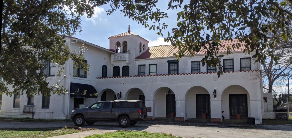
Pulling into Rocksprings, elevation 2,450 feet, we were gratified to learn that not one traffic light exists in Edwards County. Diagonally to the courthouse, we found our name on an envelope taped to the front door of the Historic Rocksprings Hotel, built 1916. The keys were under the mat. We had just enough time to stash our bags in our upstairs room before rolling one block south.

Inside the Visitors Center, we relished homemade-bread sandwiches, watched introductory videos of Devil’s Sinkhole (the day’s main attraction), and purchased tickets from a young clerk. Her dad, Andrew, soon appeared and would be our guide. They are both volunteer members of the Devil’s Sinkhole Society, which organizes outings and events. He finished the flicks, adding detail and logistics.

We boarded our vehicle and followed him in his. With his phone linked to our sound system, Andrew led us on a tour of the town, pointing out the American Angora Goat Breeders’ Association headquarters and the county jail, which sports a tower for hangings that have never happened. Only a few structures, our hotel for one, survived the fierce April 12, 1927, F5 tornado, which razed nearly all of the village in only five minutes. Alas, the burg’s original namesake springs no longer flow much. Shortly we were heading north on 377 and out of signal range.

A locked gate allows only guided groups onto the 1,861-acre State Natural Area that embraces Devil’s Sinkhole. The well-paved road led us to park next to the remarkable feature. A sturdy platform let us peer, hesitatingly, into the 50-foot-wide maw and down into an abyss. No fair dropping mobile phones! The opening shaft plunges 100 feet to a jug-shaped cavity that deepens  another 200 feet and widens to 1,081 feet. A cone of debris and guano forms Breakdown Mountain in the middle, made from material that fell when the ceiling collapsed. The hole’s three million-plus Mexican free-tail bats had gone south for the winter. When in residence, 300 of them manage to occupy each square foot of surface. Bleachers sit to one side for folks to observe the bats’ swirling exit flight each evening during the warm months. On that late-winter afternoon, we espied a only few birds and and insects.

gateway to the underworld

A retired high school English teacher, Andrew walked us around the property, pointing out local cacti and wildflowers and a bird-watching blind with a rainwater-collecting roof. The thin soils were still a bit wet from recent showers. Anywhere we saw limestone with a rusty-red tint was likely a native American hearth site. Such traces of former inhabitants were all around, but I wondered where those early nomads got their water. Our guide followed us out the gate and bid us adieu.

We returned to town and settled into Room 211, the Rancher Suite, at the hotel. On a building corner, the bedroom sported a king-sized bed, adequate TV, and walk-in closet. The anteroom featured a couple tables, cabinet, another walk-in closet, and various side and comfy chairs. The bathroom offered convenience, a sink, and a shower. Magazines and tourist brochures waited on the tables, mirroring all manner of books filling shelves in the hallways and lobby. Mrs. Mulligan, a lifelike, full-sized manikin, offered chocolates from a tray at the foot of the stairs, and her companion, James, held shot glasses behind the bar. There’s a breakfast room, formal dining room, sitting room, private dining area—all furnished in antiques. An efficient commercial kitchen was open for guests’ use. Verandas gave views of the courthouse square. As the motto attests, these lodgings are truly a quiet respite on top of the world.

We took a stroll around said square and read all the historical markers.

1891

For supper, we walked three blocks to Vaquero’s Café for migas and pork chops. That place sold no alcoholic beverages, so on the way back we slipped into the Jailhouse Bar and Grill for beer and wine.

In the hotel we at last met Debra, our beaming hostess, who checked us in. Put the leftovers in a fridge and found the backstairs, which led straight to our suite. I read a gorgeous picture book on the frontier forts of Texas, which brought to mind a paper I’d written about the subject back in college and my travels to many of the sites. Tried watching movies in bed, but could find nothing of interest. Sleep!

MoonDay, February 17, 2020. Foggy it was, and hushed in the hamlet, except for some white wings cooing, a rooster crowing, a hound barking, and an occasional motor vehicle passing. This day would have been our beloved Uncle Elmore’s 100th birthday. Lina made the first pot of coffee with our en-suite machine, and I supervised the second. We both journaled and did our morning yoga. Breakfast was leftovers from the previous evening, my first time ever to eat pork chops so early in a day. Check-out time was noon, but we felt a need to get back on the road sooner than that.

Packed and loaded, we breezed through the mist north on US 377, generally retracing our route from the day before. Time allowed us to explore all the places we’d merely passed through previously. We promptly left the plateau behind and curved along the river’s south prong, dropping in height and beholding valleys and hills. A scenic overlook afforded vistas of a wall of seeps just below. Back in the 1960s, Pearl Beer advertised itself as “brewed with pure artesian water from the country of 1100 springs,” and we figured they must’ve begun their count here. The map names such gushing features: Paint Rock Spring, Blue Hole on the Llano, Tanner Springs, Seven Hundred Springs, and Bowie Spring, among others. From these trickles comes a proud stream, and all that water eventually flows through Austin via the mighty Colorado.

a river begins

Lina’s dad, like mine, made a point of reading all historical markers along the way during trips. We pulled over near Cajac Creek and learned about the Doom of the Outlaws of Pegleg Station, a gunfight in January of 1878 between Texas Rangers and Dick Dublin’s gang of murderous thieves. They were suspected of holding up several mail stagecoaches, especially near a travelers’ rest stop on the San Saba River by Robbers’ Roost east of Menard.

Next marker told of the Four Mile Dam which, in 1896, supplied water for irrigation and power. Too, we got a better gander at the unique bright red and white crumbly limestone strata here, revealed from roadcuts. Past the state park, we were in Junction.

mission style

One of my favorite landmarks here is Las Lomas Hotel, built in 1926 by former Texas governor Coke Stevenson. It was quite the party place during the Decade that Roared and later. The building seemed in good shape, but we found no signs of recent activity. I’d love to see a medallion, renovation, and reopening. We filled the tank with gasoline and continued.

hand-tinted post card from the hotel’s heyday

Shortly came the  historical marker for Reichenau Gap, a pass between mesas, named for a German pioneer who attempted to settle hereabouts.  In London we made sure to photograph the pub, which sits by a park close to the high school. Ivy’s London Dance Hall sponsors live music every Saturday night. Ivy’s London Grocery and Grill supplies catfish on Fridays. Weekend away, anyone? A plaque fronting the Community Center discloses that the town was named for London, Kentucky. The crossroads had aspirations to be county seat. Astride the Western Cattle Trail between Bandera and Concho in the 1880s, Londoners ran businesses catering to cowboys and their ilk. Our very same Coke Stevenson lived here as a kid.

Mason calls itself the Gem of the Hill Country for its only-here blue topaz, state gem of Texas. Our Verizon phones didn’t work there. We went up the wrong slope looking for the old fort. Stopped into a thrift store for directions and to check out bargains. Half a block away was Post Hill Road, which ascended to a reconstruction of the officers’ quarters. It’s dogrun-style, meaning two rooms with a breezeway between and a common roof above.

Unlike the forts you see in movies, almost none in Texas was surrounded by a stockade. Exhibits told the story: Famous US Army generals, including Robert E. Lee, served here. We enjoyed town and countryside panoramic views, which would have been advantageous for a military installation. A model shows the original layout.

On the way down is the public library with a statue of Old Yeller out front. Author Fred Gibson was a native of Mason. Parked on the square (in truth a rectangle) and stepped into the Chamber of Commerce. Despite wanting to cut back on collecting paper, we left with a bundle of brochures, pamphlets, and maps regarding area attractions.

One block west was Square Plate Restaurant, where lunch consisted of sesame-fried chicken, deep green beans, rice, and tea. Yes, all meals were delivered on square plates. There was something gratifying about gazing across the courthouse lawn and seeing a windmill.

We steered the pickup north on Broad Street to ogle at the elegant Seaquist House from 1896. Utilizing the same kind of red sandstone as we saw in the fort, the design adds white limestone quoins for accent. Stained glass, carved rock, and wrap-around porches speak of craft and opulence. Several prominent families called the house home, but over time the palace fell into neglectful decay. A local foundation offers tours and is engaged in total restoration. Remarkable is the third-floor ballroom.

almost spring

Eastbound on TX 29, we paused in Llano to check out the Dabbs Railroad Hotel. Built in 1906 when Llano was the terminus of the Austin and Northwestern Railroad, this rooming house catered to train company employees who would spend the night before returning eastward on the train the next day. Other folks could also stay there, the most notorious being Bonnie Parker and Clyde Barrow and their gang. Yours truly presented a talk about area geology and history here back in the 1990s. Today, the spiffed-up facility promotes itself as an event center for weddings, parties, and weekend getaways.

That’s the Llano Piano on the porch.

Keeping our pace, we breezed through Burnet and Liberty Hill and got back to our little Fig Cottage by late afternoon. Amazing what you can see in just a couple days’ drive around Central Texas.

Thanks for reading!


grassy hillside ccThere’s a desire that builds in me after too long a time away from Trans-Pecos Texas. The final winter weekend of 2016 presented an opportunity to scratch that itch when I learned that the Nature Conservancy’s Davis Mountains Preserve would be open. Lina and I chose to combine this year’s wedding anniversary trip with a hike in that seldom-accessible property.

Thur, 03-17: My phone alarm broke our slumber at 4:55 a.m. on Saint Patrick’s Day, and up we sprung. Threw all last-minute items together and into Twinka, L’s two-door Hyunda, and rolled out at 6:00, while outside was still dark. Streets weren’t badly crowded, but we marveled at the steady stream of cars heading into town. A light mist dampened our windshield. Westward ho!

Isaack'sDay dawned by Fredericksburg, and the sprinkling abated. Seamlessly we merged onto good ol’ I-10 and attained 83 mph. By tradition, first stop is breakfast at our favorite café in Junction, where we arrived at 8:30. Helen is the very same waitress who’s worked there since I first began going west in the mid-1970s. She claims to remember me. The Junction Special consists of two of everything: bacon strips, sausages, pancakes, and eggs over easy—all washed down with steaming coffee.

Oop sign cuAfter filling Twinka’s tank, we were under way again, on and on, zooming past Sonora and Ozona, crossing the Pecos at Sheffield, exiting onto TX 349, which followed the Pecos into Iraan. There I showed Lina the city bathhouse and Alley Oop Park (where my first family had camped when daughter Kristiana was young). There we posed as Alley and Oola. HowLin Oop Oola

Alley Oop

The Iraan Museum wasn’t yet open, but we chatted with maintenance man Tory, who answered questions about the facility and our next destination. Would have gassed there, but a computer reinstallation nixed our chosen pumps.

Castle GapWinding west on US 190, we turned north onto TX 305, crossed the Pecos again, and shortly found McCamey. US 385 then headed to Castle Gap Road, which we traced a mile east or so to get a photo of the Gap. It was a major trail landmark and route in stagecoach days. Amazing. Back in McCamey, we gassed yet again, then continued non-east on 385.

Noticed well-watered fields on the approach to Fort Stockton, and again towards Balmorhea. Flowing irrigation ditches led us to Uncle’s Convenience Store, the one we’d found on our 2014 California trip. There, we bought thick and crispy potato chips, our only food since the yuuuge b’fast.

TX 17 offers a terrific introduction and advance to the Davis Mountains. I especially love Wild Rose Pass, which edges Cieniga and Chihuahua Creeks. Before long, we pulled up to Fort Davis’s Butterfield Inn and stepped inside Along the Trail Antiques.Lee's Wild Rose Pass

Kelly Prude checked us in and escorted us to Cabin 2, set in the southwest corner of a compound of three others of identical—though mirror-image—other ones, each with a brick and native-stone fireplace. I guessed the dimensions at 18 by 21 feet. Above the queen-size bed was a vaulted ceiling. Main room had a big La-Z-Boy couch jammed into the bay window and a drop-leaf table up against the teal-painted far wall. No other opening illuminated the interior. A TV occupied the northwest corner on a triangular shelf, and the fridge, microwave, and armoire fit the northeast. A closet and bathroom sat on the left end of the space. After bringing our effects inside, we shifted the couch to the foot of the bed and placed the table in the bay, curing any awkwardness.

Looking for info and maps of the preserve, we strode to the Chamber of Commerce, which offices in a former feed store. It was closed, but we helped ourselves to several brochures. Adjacent was the library, where director Toi Fisher greeted us with a 3D printer and lots of great data on hiking and dining and building history. She spoke highly of Maddog’s Cantina, just around the corner in a structure we remembered from our 2007 visit as a pizza parlor.

Figuring to cook and eat in, imagine the shock and shame when we realized we’d packed no utensils. Plan B: go to Maddog’s. Funky and ramshackle it was, with a big bois-d’arc poking through the roof. Only two other tables were taken when we sat down. E_____, the one waitress, took our order. Dismayed were we when the burger and veggies came 40 minutes later and not to our specs. The place filled up as we finished. After pointing out the establishment’s foibles and learning that the credit system was nonfunctional, I handed the embarrassed serving girl a five and a twenty.

Next door, a dollar store supplied us with our forgotten items: a couple ceramic bowls, a pair of oversized coffee cups, four dessert spoons, and two stemless wine glasses—all for a mere ten bucks.

In the room, we settled in to watching 50 First Dates and Hogan’s Heroes, the latter not aging well. Finally got to bed after surrendering to my laptop’s connectivity stubbornness.

Friday, 03-18:  No alarm this a.m. Cloudy in Fort Davis, 34° at 8:11, NE winds, quiet except for Eurasian collared doves cooing and the family next door stirring. Lina did online research into the artist Arthur Tracy Lee, whose book of Fort Davis paintings I committed to gifting her. Annoyingly puzzled over how the expletive I could have neglected to bring my black wool beret, I questioned my experienced traveler qualifications.

Lina was chomping at the bit to get on out and head for the high country. She packed meals and snacks. After a nagging time getting out the door, we were at last underway after 9. A bright day illumined our road into the mountains along Limpia Creek past McDonald Observatory, which now boasts another dome on a nearby peak. Plenty of cholla grew along the way, but none presented itself for harvest.

Just past the Madera Canyon roadside park opened the new gate into Davis Mountains Preserve. Pulled up to the spacious visitor center and stepped inside. Cruciform, the central square of the edifice features a soaring roof with windows all around in every direction and exposed wood beams. Off to the left side of the entryway stands an office; to the right is one of a couple dorm rooms with six bunk beds each. The southeast corner features rest rooms with showers; NE wing contains a spacious kitchen. In between are lounging, presentation, and dining areas.

center lobbyGreeting us were Dierdre (last syllable pronounced ah) Hisler, project director, and Gary Freeman, a retired UT botany professor and volunteer. They oriented us to the situation: no driving Twinka on the rugged and rough road into the property’s heart, but we could likely hitch a ride with better-equipped patrons. Almost immediately, a tall fellow with a gray beard called me by name. It was Don Alexander, fellow Kerrvert and biologist who comes on my Quiet Valley Ranch nature walks. With him was his niece Alison James, a Nature Conservancy employee in Montana, twin of Wendy of Ike and, utterly remarkably, cousin to my Capitol co-worker James Chapman. Also along were Uncle Ian, an older man with a cane. Who else should walk in but Scott Newsom, our Austin buddy Leigh’s brother. To our heaping gratitude, Dierdre loaned us her personal vehicle, a white four-wheel-drive, four-door Tacoma. Off we went.

Mt Livermore portraitThe 4.9-mile lane offered plenty of creek fords and bumps, against which I held on mightily to save my beleaguered crooked spine. Just past a wind pump and empty iron tank at the end of this road, we parked and set out up a jeep trail that led to a narrower path. Our goal was Tobe Spring, the name reminding us of our best friends back home. Up and up we ascended. Don knew many plants and trees, and I knew others, introducing him to the manzanita, madrone’s cousin. We all marveled at the silver-leaf oaks here and the frequent ponderosa pines. Also painfully evident was the massive wildfire that swept through here in 2011, consuming 60,000 acres in its rage. Drought increases in this now-warming world. I apologized to the grasses and forbs for us civilized humans’ fault.silver-leaf oak cu

Saw a red-tailed hawk and a couple woodpeckers, heard one or two high-altitude planes. Otherwise, things were quiet enough to whisper. At one point, Ian stopped and the rest of us strode on. Photo’d L under the champion ponderosa pine. Closer and closer we came to Livermore’s baldy knob and eastern cliff, but could spy no humans up there.L under chamPonderosa cu

Stopped by an algae pool for lunch: avocado and cheese sammiches with hard-boiled eggs. We each brought precious drinking water in our Zion National Park vessels, mine a purple collapsible pouch. I rested on prickly pine mulch and closed my eyes while Don and Alison climbed up a bit farther.

H&L by algae pool cuAll done with repast and relaxation, we descended, using different muscles. L’s knees gave trouble. I experienced shortness of breath from the 7,000-foot altitude, but otherwise fared well enough. Rejoined Ian and got back to the vehicle around 3:00.

Bumpity-thud back to the center, we asked a gal for a group shot of our merry crew. Inside, we drank more lemon water, sprawled on a couch, and conversed with our gracious hostess. Folks arrived in a steady stream, each getting the same earful about trails, camping, programs, and facilities. I pledged my support to Dierdra, who will soon initiate a Friends of the Preserve club.merry crew in DMP ccu

Saying our reluctant so-longs, we traipsed out to see Scott’s curious camping trailer, which metal lids form work surfaces. From racks hung a towel plus pots and pans and lids. An open grate by yon tongue supports his propane tank and fuel bottle. A tailgate holds a spigoted jug of water. Various boxes contain everything else. The whole device operates quite efficiently but without the Chuck Wagon’s charming personality—just sayin’.

The famed Davis Mountain scenic loop took us 45 miles back to the town via Sawtooth Mountain, Rock Pile, the road to Valentine, a much-built-up Bloys Camp Meeting, Davis Mountain Resort, Point of Rocks, and sweeping views of high-altitude grasslands. The 25-mph speed limit at the village square appealed to me. Back in our cottage, we drank beer, wine, and wodka and ate soup. Much resting ensued, and I wept from music such as that of Joan Baez, Grace Park, the Roaches, Cocteau Twins, and others. I edited L’s latest novel chapters, and we watched Perry Mason, Twilight Zone, and part of Dark Knight before crashing for good.

Saturday, 03-20: Awakened to a cold and cloudy last day of winter. Bundled up as much as possible by donning navy trousers and two long-sleeve t-shirts beneath an orange Oxford. First stop: thrift store adjacent to a stone former tourist court across from a current tourist camp. Providence provided me with a $5 Scottish wool Trilby, which matched my coat’s lining. We chatted with the cute young clerk there and with the enthusiastic fellow out in the gallery, located inside one of the former lodging rooms.

Officers' RowAt the fort, Ranger Bill Manhart gifted me a roster from the 1870s, which showed that my great-grandfather “H. Frick” earned $75 per month as a blacksmith. Walked through exhibits in barracks, officers’ quarters, the hospital, and a Native American wikiup. Took photos and kept warm. At Bookfellow, paid $75 cash for Captain Arthur T. Lee’s frontier landscapes in an out-of-print volume.madrone trunk

Refueled and steered south on TX 118 to Chihuahuan Desert Research Institute’s Nature Center, joyfully greeting our hiking companions from the day before. Ralph the volunteer checked us in and sold me guides to the Botanical Gardens, where Lina ambled, and Modesta Canyon Trail, where I stepped. My path plunged steeply into this crevice where two distinct geological formations butt together: Sleeping Lion rhyolite and Weston basalt. Scrambling was fun, and at the bottom I marveled at the gurgling trickle, little ponds, several birds, and blooming mountain laurel and madrone. Shot a one-minute video of this panorama, which you can see here (111 Mb file).

rock pillarsUp again, past rock pillars and sweeping vistas (now sunny) and back to the center, where L and I sat on the porch to enjoy cheese and guacamole on sprouted bread while gazing out towards Livermore. Marvelous there was the display of Earth’s geologic ages, with representative rock samples from each. Missed the mine exhibit, but found the whole experience most delightful and highly recommendable.

Tall RockWound down Musquiz Canyon past Mitre Peak into Alpine. Found Museum of the Big Bend behind Sul Ross State University in a 1937 lamella-arched stone building. Fab was the Tall Rockshelter panel and Livermore Cache. Ditto the surveying display and Tom Lea’s art.

Paisano Peak cuZooming westward, we learned that Paisano Pass’s name came when two Spanish explorers greeted each other (paisano = countryman) here. This is the highest elevation (5,074 ft.) on the Sunset Limited railroad line. Took a fine shot of the peak, as well. Continued past the lights viewing installation and into Marfa (named for a character in Brothers Karamazov), listening to its public radio, KRTS.

Circled ‘round the scales-less Presidio County Paisano interiorcourthouse and parked at Hotel Paisano to explore. Almost a carbon copy of Van Horn’s Hotel Capitan, here Giant runs 24/7, and the place oozes hipness. Declining to drink or eat the high-dollar offerings there, we tried Planet Marfa from an online listing. It was way cool, but offered only chips and salsa. Mando’s on the town’s west end brought us satisfying enchiladas, chile rellenos, and Big Bend Brewing Tejas Lager.

wood-fired hot tubLiz Lambert’s El Cosmico amazed us with its uniformed desk clerks, wood-fired hot tubs, Mongolian yurts, hammock grove, group kitchen, canvas-walled outhouses, tipis, safari tents, cozy lobby, and colorful vintage trailers. Stopped at the former-gas-radio station and met Joe Nick’s engineer during his Texas Music Hour of Power. He’d been there the week before.

As dusk overtook, we retraced our route ten miles east to the viewing area and angled Twinka southwest towards the Chinati Mountains. Even before complete—though moonlit—darkness, lights appeared way out on the horizon. L remained skeptical and even bored as we attempted to discern patterns in the locations and twinklings. The state-supplied structure gave some shelter from steady north winds, and I overheard at least one local gentleman verifying my memory of flashing orbs and hues. Endured until 9:35.

The waxing Worm Moon outlined a few roadside peaks on our way into Fort Davis. Remarkable was the lack of streetlights in town, a nod to the observatory’s dark skies initiative. We readied our bags for an early departure, drank beer and wine, and performed ablutions. I set the alarm for 4:01.

Sunday, o3-20: Rolled out of Fort Davis at 4:40 a.m. under pale lunar illumination. Could just make out mountain silhouettes as we steered down Wild Rose Pass. Bizarre was seeing red lights of the wind generators blinking in unison. Sun rose precisely in the east on that Spring Equinox just past Ozona. Pulled into Fig Cottage, our Upper-East Austin home, at 11:30 a.m. after 424 miles.

When can we go again?

Here’s a guest post:

Austin holds a reputation for being a strange place. What are the most bizarre aspects of this creative city?

Imagephoto: propertytaxloansfortexas.com

Red Wassenich would never have imagined what he started probably as a novelty and a mild shocker would turn into a monster. Neither could he have foretold that the city of Portland would ape the theme with its own Keep Portland Weird. The Keep Austin Weird idea had arrived and taken root.

What is weird about Austin? Does calling itself the live music capital of the world constitute weirdness? It should, one thinks. Not even Willie Nelson living in Austin (instead of Nashville that could pose some serious opposition to the self-proclaimed nomenclature) can qualify the city for the name. For New York can hardly be called the movie capital of the world just because Woody Allen makes his home there.

No one can dispute the Cathedral of Junk’s weirdness, which took 700 bicycles to build. Before his demise, you could go meet the cross-dressing mayoral candidate Leslie to learn about the city. While it lasted, the cook-off called Spamarama would surely take your breath away.

Another book, Weird City: Sense of Place and Creative Resistance in Austin, Texas, sticks to Keep Austin as the focal point of an exploration that seeks to make sense of the place, urban politics, consumption patterns, and sustainable development.

Keep Austin Weird as a slogan was adopted by the Austin Independent Business Alliance with a view to promote small business in the city. Red Wassenich put up some resistance, but the phrase slipped from his grasp, though he still has some kind of ownership of it with his website keepaustinweird.com. He also published a book named Keep Austin Weird: A Guide to the Odd Side of Town.

Outhouse Designs, which wrenched the slogan from Wassenich’s hands, markets various things like T-shirts, mugs, and hats.

In Austin, the traditional way of looking at jobs has taken a new meaning. Whether you are a bookstore clerk, a lawyer, a doctor, or a computer professional and you earn your living by such work, you do not consider it your job. So, what constitutes jobinAustin? The real work goes beyond these materialistic occupations. Music and art are some of these “jobs.” Collecting old vinyl of Bob Segar or even Popeye mugs are properly called work here.

Take parenting: Kids are left alone to have the time of their life at outdoor play or at ice cream parlors. Parents meanwhile are content to seriously nurse bottles of Lone Star beer and may compare body piercings. Do not be surprised to see this all-pervading patio culture in bars and restaurants where the outdoor annex might be bigger than the indoor space.

The slogan Keep Austin Weird may sound frivolous, but there is a strong undercurrent behind it. Residents of the city are not about to let big corporations make a foray in to the city. Their support for local business is total. Weird or not, Austin means business.

About the author:

Jenny Corteza loves to read and write. She contributes articles to a number of websites online, some of them being about travel and owning a lovely luxury villa in Thailand. She also runs a bunch of blogs for her followers and is mighty active on various social media platforms as well.


Youth camps have graced the Kerrville area of the Texas Hill Country since the 1920s, but Presbyterians were the first denomination to start a summer church camp there. Methodists, Lutherans, and Catholics soon followed suite. Currently, one can visit nearby Mount Wesley, Camp Chrysalis, and TECABOCA.

Mo Ranch is a 500-acre conference and camp center west of Hunt, which is west of Kerrville. Formally a Conoco Oil Company retreat, Mo Ranch takes its name from corporate executive and former owner Daniel J. Moran, who created much of the grounds’ singular infrastructure with repurposed oilfield pipe and locally quarried limestone. The Presbyterian Church acquired the property in 1949.

Map of Mo Ranch

Map of Mo Ranch

I first visited Mo Ranch as a child when Dad took me there during one of our annual summer vacations in the hills. We stayed at Casa Bonita Lodges on the Guadalupe River’s South Fork. Nearby stood the Helter Skelter Shelter and the Hodge Podge Lodge. One morning, while the rest of the family (three sisters and our mother) enjoyed other activities, the males drove around to the Guadalupe’s north branch. Nine river crossings separate Hunt from Mo. Even on that first visit to the resort, I remember the renowned slide, down which thrill-seekers ride a short board into the river. Somewhere there’s a photo of young me standing next to the slide. In the early days, the narrow highway wound through the property; today, a new bridge bypasses the former entrance.

After attending junior-high-age Camp Aranama, the logical next step in my maturity was to go to Mo, which I first did as a camper in the summer of ’69. It was then that I met Sallie H., whom I regarded as my best girl, though she didn’t. Boys stayed in the River Dorm, girls in Loma Linda. During the week-long outing, we campers listened to contemporary songs such as The Sound of Silence and discussed them, always with a Christian slant. Canyon wrens would serenade us during dances and services in the auditorium. We ran across the catwalk, which floor you could see through, daring each other to look down. We’d drop toast off the structure to see if it would bounce. I took walks next to the Guadalupe and marveled at old outbuildings. The promise of romance electrified every encounter.

We enjoyed Cokes in the Teen Canteen and bought James Avery jewelry in the book store. I learned about Malcolm Boyd and Marshall McLuhan, buying their books. I’ve still got The Medium is the Massage and later discovered an audio version. Those ideas would be pivotal in my communications studies at UT later. Summer of ‘70 was the year Hurricane Celia hit Port Aransas dead-center. I had escaped to Mo earlier that week, and heard that Corpus was destroyed—an exaggeration. I also went to a choir camp at Mo one off-season, from which I still cherish the sheet music.

Sallie proved to be a powerful attractant to my getting to Austin, along with my big sister’s pioneering move there. Ironically, Sallie left Austin just as I arrived.

Presbyterian University Students at Mo Ranch, 1974

Presbyterian University Students
at Mo Ranch, 1974

I attended a bible church for my first couple terms at UT, but returned to the familiar Presbyterian fold in my junior year. That meant more trips to Mo, mainly for retreats during fall, winter, and spring. The photo shows one such visit. That’s me on the far right addressing our group outside the River Dorm. I’m not sure what I’m saying, but a good guess is a recitation of Prinderella and the Since, which I’d memorized back in high school for speech tournaments. My travel log records this trip on April 26, 1974, dutifully counting those nine river crossings. With each bridge, excitement would grow. A similar church group returned to Mo another time, camping at The Rapids just upstream of the facility’s more developed areas. On a different occasion, I provided music for a dance in the auditorium.

Flying Roof Yurt at Mo Ranch, 1975

Flying Roof Yurt at Mo Ranch, 1975

After obtaining my first degree (RTF) in December of ‘74, I was footloose and fancy-free for a few brief months. In early 1975, I heard about a hands-on workshop happening at Mo Ranch, so out I went. This was my first meeting with William S. Coperthwaite and my first time to help build a yurt. Bill, as he’s known, designed the modern yurt, a permanent version of the nomadic tents used for centuries in the steppes of Central Asia. Under Bill’s direction over a couple weekends, a crew of volunteers erected two nine-sided yurts just north of the catwalk. Each featured a flying roof of cylindrical sections. We’d hammer and saw by day, then hold conversations about architecture and social design in the evenings. These unique structures were meant to be staff quarters. The yurts lasted several years, but were, unfortunately, razed when new, unimpressed management took over. I, however, began a long relationship with Dr. Coperthwaite that continues to this day and that led to my building two yurts of my own.

Mo Ranch exemplifies a place of significant life happenings. The Hill Country is a special place on its own, but Mo became an even more extraordinary slice of those hills. Everything that makes the region attractive I found at Mo Ranch: juniper tree aromas, distant vistas, cold running waters, stout limestone ledges, and indigenous wildlife. Add to that physical beauty the important experiences of adolescent infatuation, hard work, deep thought, and fun times—and Mo remains unforgettable.

June 8, 1974, from the HWR Travel Log:

On that Saturday, I was exploring southwest of Austin. I remembered that my high school algebra teacher, Turner Ferguson, taught riflery at a camp called Friday Mountain Ranch during the summers, so I drove into that gate to look for him. This was only three years since I’d graduated from Corpus Christi’s W. B. Ray. Once inside, I asked a staff woman who told me that Mr. Ferguson hadn’t been there in a while. In my usual way, I inquired about the camp itself and read a historical marker near a venerable limestone building. Here’s what I learned:

Johnson Institute from the South, 1936

Johnson Institute, south elevation, 1936

The Johnson Institute was founded in 1852 by Professor Thomas Jefferson Johnson from Virginia. In 1868, he built the impressive two-storey, ten-room structure, which housed offices and students in residence. The school endured until 1872, after which the property changed hands several times. Another teacher, Dr. Walter Prescott Webb, purchased the 630 acres surrounding the Institute in 1942. It was Webb’s idea to start a youth camp at Friday Mountain Ranch, which admitted boys first and girls later. Surveyors had named the prominence for the day they discovered it.

I didn’t stay at Friday Mountain but about half an hour, then continued on my journey. It wasn’t until later, though, that other, more interesting facts presented themselves.

I minored in geography for my first degree at The University of Texas at Austin, then sought a bachelor’s in that discipline in 1977. I enrolled in every class I could find that contained the word Texas, especially history and geography, so before long I was reading books by the above-mentioned Webb and J. Frank Dobie and Roy Bedichek. They were each associated with UT and were also close friends who spent much time together debating great ideas. Schools in Austin are named in their honor, and a statue depicting them in lively conversation greets patrons of Barton Springs Pool, one of their favorite hangouts.

Texpert with the Three Friends

Texpert with Bedichek, Dobie, and Webb

The three Gentlemen of Letters often stayed in the fortress-like structure at Webb’s ranch. It was there, on the second floor of the south wing, that Bedichek secluded himself during the entire year of 1946  to write his first book, Adventures with a Texas Naturalist. In it, “Bedi” skillfully weaves philosophy, art, and observations of the Texas landscape. The tome’s been a great influence on me, giving rise to the signature line below my tour company e-mails: “Adventures with a Texas Geographer.”

Friday Mountain hosted co-ed camps through the 1980s. In 1991, the International Society of Divine Love bought the land and wrought extensive changes. Today, it’s one of the largest temple/ashram complexes in the US and the oldest in Texas. The beautiful grounds and classic Hindu architecture form the setting for festivals, worship, dance, and yoga. I enjoy pointing it out on my Hill Country treks. Its current impressiveness, however, comes at a woeful price: the designers so altered the old Institute’s structure that no hint remains of its original function or heritage. New windows, doors, and roofs completely mask the vernacular stone. Even the nineteenth century founders’ graves are relocated. Consequently, in 1992, the Texas Historical Commission revoked the building’s official designation, its original integrity lost.

It seems tragic to me that historical marking coveys so little protection on old monuments such as this. Now, folks such as myself must tell the missing tales. What do you think?


Travel Log, Vol. I

HWR Travel Log, Vol. I

Although traveling and exploring Texas has been my life-long pursuit, I begin earnestly to do it in 1973, just after buying my first automobile. Still at UT studying radio-TV-film and living just off campus, I could walk to class, but on weekends drove my car. The Dodge Dart Sport Convertriple was so designated because it was three vehicles in one: a regular five-person sedan with a sunroof like a convertible and a fold-down back seat and openable trunk that made it a cargo carrier. For its blue color, I named it Humphrey Blowdart.

Desiring to keep a record of areas visited, I bought from the Co-op a small spiral-bound notebook, which became the first volume of my travel log. Its price tag testifies to the march of time. Not yet possessing a clever nickname, I was just HWR in those days, so that was the journal’s heading. The subtitle: “consisting of notes, observations, facts, stops, and distances of trips taken between March 8, 1974, and June 18, 1977.” The format was columns headed by Date, Mileage, Place, Route, and Time, with a new entry for each halt or road change. In the beginning, Humphrey showed a mere 8,246 miles on the odometer; the last notation in Volume I was 53,071.

Inside the log’s front cover is taped a list of official national CB 10-codes, a vivid reminder of the “breaker one-nine” fad. On the second leaf is a three-year calendar clipped from an almanac for ‘74 through ‘76. On the back pages and scattered here and there are budgets, calculations, and random scribblings, including the draft of a letter to a judge after I was awarded a speeding ticket.

Lots happened between those trips. I moved from the center city to the southeast part of Austin, finished my first degree, built my first yurt, began working in the Capitol, lived at scenic Rancho Richey (before it was a refuge), attended a Willie Nelson Fourth of July Picnic, began my broadcasting career in Fredericksburg, worked at the UT ID card center, went nuts over CB radio as the “Earth Brother,” bestowed on myself a catchy title, moved to Uvalde to work in commercial radio, moved back to my beloved Austin, took several geography courses, and slacked in scads.

All this information forms the basis of my upcoming memoir/guide to Texas travel. The log and its subsequent three volumes literally tell my life’s journey, just as the Party Pages relate my history as a series of celebrations. Both convey the joy one guy feels while doing what he loves.

How would you write you autobiography?

Meadow near Goliad

Meadow near Goliad

I’ve traveled back and forth from Austin to Corpus Christi probably hundreds of times, still making new discoveries every trip. On a recent weekend, though, I reached back to a distant, personal past.

My first night out away from family as a teenager was during the summer of 1965 or ‘66, early in my junior high experience. Raised Presbyterian, I got to attend a retreat center called Camp Aranama, just outside of Goliad, run at that time by the South Texas Presbytery. Aranamas were natives who lived there long ago, a band related to the Tawakonis and for whom 18th-century Spaniards built several missions.

Campers arrived on a Sunday afternoon and said farewell to their parents. The whole split into four separate groups, each consisting of five boys, five girls, and two adult counselors of corresponding gender. Every kid brought bedding and clothes. We slept in “hogans,” which were wooden-framed structures covered in canvas and netting. Each group cooked its own breakfast and supper and performed chores. Lunch happened with all four groups together in the central recreation hall.

Typical of such church-oriented operations, our schedule included religious study, learning outdoor skills, swimming in the pool, and gaming. The highlight of our week was the hike. We took off cross-country, first to the Big Tree—an enormous old live oak with branches that grew to the ground, forming an enclosed shelter and offering shady rest. From there, we continued to town to see the presidio and mission and learn the area’s rich history. A van or small bus gave us a ride back to the camp.

Come Saturday, the experience drew to a close and everyone went home, rugged and tanned and happy.

Derelict Camp Aranama Hogan

Derelict Camp
Aranama Hogan

I’d visited Goliad on many occasions in recent months, but at last determined to find the camp this trip. It’s now Aranama RV Park. I drove in and promptly met the proprietor, Bruce Jones. He’s also from Corpus and is a day younger than I. He told me that his family had acquired the property in 1990 after the place had been “abandoned” for two decades. The Joneses built sheds for vehicles and equipment and installed hookups for numerous trailers. They also enclosed what had been the rec hall. The swimming pool was fenced and unused. Bruce showed me a fading photo of one of the hogans, now likely returned to the elements.

I also looked for the Big Tree, following the circular road around towards a bend in the San Antonio River. The tree wasn’t evident from my vantage points, but the broad grassland with scattered live oaks and anaquas provided a pleasing green panorama, especially after a rain shower watered the sandy ground.

It’s pleasing to discover that those acres still cater to campers, albeit older and less rustic ones. It’s also meaningful for me to reconnect with the site where began my long experience of tents, fire circles, and fun out in the woods.

What was your first camp?

Lina at Palacios Seawall

Lina at Palacios Seawall

It’s a tradition for Lina and me to commemorate our wedding every year by sleeping in a historic hotel or bed and breakfast. For our seventh this April, we added two other criteria: the place must be next to the ocean and a destination where neither of us had ever been. Tall orders? Filled!

It was Maundy Thursday, so traffic was slow getting out of Austin. We got to Gonzales just about dusk, but found no good restaurants. We grudgingly settled for Whataburger, but it was the last supper we’ll ever try there on a holiday evening.

At Yoakum, we diverged onto TX 111, which took us southeast across the Lavaca River and parallel to the Navidad. At Mount Olive (appropriate to the day) during a brief leg-stretch, we heard a fabulous amphibian chorus. Darkness surrounded us, but the almost-full moon arose to guide our way.

All we remember about Edna was its theater’s brilliant neon sign. Crossing Lake Texana was a bit surreal in the moonlight, but we knew our destination was getting close. At Midfield our route veered due south, and at 10:30 we pulled into Palacios.

This is a beautiful location overlooking Tres Palacios Bay, which is one of three smaller arms of Matagorda Bay. By our arrival, the big moon shone over the barely rippling waters. Except for a few fishermen’s low voices out on the pier, the waterfront park was refreshingly quiet.

Peaceful Pelican B&B owner Edith greeted us on the wide porch, showed all essentials, and left. We had the whole place to ourselves and explored the many corners. The McGuire House dates from 1910, built by an educator for herself and family. Martha Pearl McGuire taught music and performance upstairs, and a preparatory school stood out back.

Today, the rooftop widow’s walk is accessible from the third-storey attic suite, itself large enough to sleep six. We occupied the spacious Magnolia Room, which featured a king-size bed and bay window facing the sunrise. Per Lina’s wishes, the private bath included a clawfoot tub. It was late by the time we closed our eyes.

Returning in the morning, Edith prepared us a breakfast of fruit-stuffed French toast. Also at hand were plenty of coffee, tangelos, sausage, and juice. Unquestionably a local authority, our hostess regaled us with house and village history. On Edith’s urging, we set out to explore the bayfront on foot, first strolling to a nearby antique boutique.

HR with Pearl, the Peaceful Pelican

HR with Pearl, the Peaceful Pelican

After gathering out things and checking out, we drove to the Luther Hotel, which dates from 1903. Originally facing East Bay, the structure was moved to its present south exposure in 1905. Still in business, this venerable wooden inn personifies quaintness. Just offshore from the lodge stood a series of circular pavilions. One from the 1930s and 40s hosted popular swing dances, housed a café, docked sailboats, and supported folks fishing. Over time, each of these fabrications met its destruction when tropical cyclones careened ashore.

High winds are a fact of life along the Coastal Bend. Record storm was Hurricane Carla, which struck Matagorda Bay dead center on September 11, 1961, armed with 171-mph gusts. On that date, I was a nine-year-old lad living not far down the coast in Corpus Christi. That howling night, my family slept in our home’s hallway away from exterior walls and windows. Only a transistor radio connected us to the outside world. Carla caused a 22-foot tidal surge that flooded most of Palacios, including a foot of water in the McGuire home.

Other momentous events from the past shaped this seaside town. The French explorer La Salle’s misadventure happened just around the corner on Lavaca Bay in 1685. Uncovering his wrecked ship Le Belle was a major archaeological feat for the area in 1995, and Palacios provided volunteers and infrastructure to the artifacts’ recovery. Lina and I visited Edith at the City by the Sea Museum, where she works when not renting rooms. Situated in the historic R. J. Hill Building downtown, the displays bring La Salle and Carla to life.

Hotel Blessing lunch buffet

Hotel Blessing lunch buffet. Photo courtesy Texas Bob

On our way north again, we lunched in the coffee shop of the equally vintage 1907 Hotel Blessing in that town. For a decent price, we feasted on the daily buffet of veggies, macaroni, potatoes, several meats, tea, and cobbler, most served up from two classic cookstoves. We also learned about A.H. “Shanghai” Pierce, an important regional cattle magnate, and visited his grave.

With the usual reluctance and joyful feelings, we retraced our route northwest, seeing beautiful scenery in the daylight that we’d missed before. T’was a brilliant spring, and we’ll likely return to those lovely Texas bays.

Platt Crossing

Platt Crossing

Austin’s outdoors hold many hidden gems. In particular, I just rediscovered a public place that isn’t a park or preserve per se. The Austin Water Utility owns frontage along 3.5 miles of the Colorado River’s north bank near Bergstrom Airport. The 1,200-acre Hornsby Bend Biosolids Management Plant offers a major bird observatory, manufactures Dillo Dirt compost, hosts the Center for Environmental Research, and partners with several ecologically minded organizations. Among them and headquartered in an ecohouse on the Hornsby Bend site is Austin Youth River Watch. They held a party last weekend that featured a walk though woods down by the riverside.

Fellow geographer and guide Elizabeth Welch, who directs the youth programs, is a wealth of information about the flora and fauna there as well as their cultural uses. She led us past several ponds and tall stands of wild rice to the Colorado’s edge, which had been the historic Platt Crossing.  In view were violet henbit, catchweed bedstraw, variegated bull thistle, and teeny speedwell. We saw evidence of beavers and heard that otters were nearby.

Pecan: State Tree of Texas

Pecan: State Tree of Texas

At the end of the trail was the biggest pecan tree I’ve ever beheld. Leaning downstream from some ancient flood, this gargantuan being overwhelmed our little group. Six of us couldn’t have joined hands around it. On the ground were remnants of last fall’s nuts—the small native type. Still dormant, this and other Carya illinoensis will likely bud in April. The tree would have witnessed the Hornsby family’s arrival here in 1832.

In collaboration with Travis Audubon, Hornsby Bend offers frequent owl prowls at night and other birding events. The facility is open to anyone every day from dawn to dusk. The Center is accessible off FM 973, and the nature trail is at the end of Platt Lane.

SA to Henly

SA to Henly

When I know the route my clients use to get to or from Austin, I often suggest things for them to see. Here’s what I wrote for four Canadians recently:

My tour to the Alamo City goes along US 281, one of the prettiest highways through mid-Texas.

You’ll probably notice a strong German influence in San Antonio and in areas north and west. Look for Teutonic names on street signs and villages.

A few miles north of the Texas 46 intersection, you’ll cross the Guadalupe River, perhaps the state‘s lovliest. Beneath the bridge, behold a couple canoe and inner tube liveries that outfit floating and paddling on those swift rapids.

The crossroads of Twin Sisters gets its name from two matching peaks just to the west. They stand on the divide between the Guadalupe River basin and the Blanco River valley.

In Blanco proper stands the original courthouse from 1885 when Blanco was the county seat. Uptown Restaurant serves decent meals, and you can take a short walk into the municipal park to see the second-oldest live oak in the county. Also there is one of my favorite regional breweries, Real Ale, which makes Fireman’s Four and Full Moon Rye.

Please use Ranch Road 165 as a shortcut to Henly. This skirts the river for a few miles. Just past the 2325 junction is Peyton Colony, a Black freedman’s community founded after the US Civil War. You’ll then notice a long upwards slope. Just before the summit, safely pull over and look behind you for one of the grandest views in Central Texas. This is Singleton Pass, which marks the divide between the Blanco River and Onion Creek, a tributary of the Colorado. The Twin Sisters show prominently on the far horizon.

Past Dripping Springs, you’ll begin to see suburban Austin.

There’s more, of course, but these few factoids should enhance your experience a bit. Remember, safety is no accident!